I live here
25 Février 2005
Some days ago, a friendly otter asked me where I lived. Here is my answer, in pictures. Not only I can spot the MGH hospital building where my research lab is, and even the greenhouse, but on the same final image, I can also see my street, and almost the exact place where my appartment is. Fabulous. It reminds me a lot this fascinating movie I saw when I was a kid, in the seventies, called "Powers of Ten", which is reviewed here. You have an interactive version of a similar idea here (Java required).
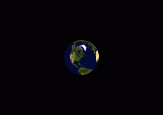
This was done in ten minutes with the incredible open source software for Windows World Wind made by NASA. You need a lot of space and a lot of bandwith to make it work smoothly, due to the amount of data manipulated and calculated in real time, like fine satellite images from databases used as textures. It looks like only the United States surface is completely covered. I hope there will be more later, or they can use satellite images databases from other countries. I would love to zoom on my parent's house in the south of France.
It's very interesting to check various places like New York (which shows for example that the Manhattan images were taken before September 11 2001), the Mexico / USA border around Tijuana, the Florida Coast, the Grand Canyon. Beautiful work. It should be available for all kids (and virtual grown-up kids) everywhere to learn about geography, astronomy, urbanism, ecology, everything that concerns our little blue dot. Thanks to Corsac for pointing to this wonderful piece of software.
[Some batch image editing and conversion was done with IrfanView, an excellent and powerful image viewer which is freeware (as in free beer) and around 400 kb in size, and the small animation was done with UnFREEz, an animated GIF creator, which is free and 20 kb in size, made by the same author of the extremely useful SlimFTPd FTP server (size :15 Kb !). Sometimes you just have to love computer programmers. Hmm. Maybe not all of them.]
[guillermito a gmail com] - [Home]